
Image Details
Kenneth Nebenzahl from Maps of the Holy Land New York: Abbeville Press, 1986
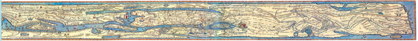
The Roman World, from Britain to Ceylon, appears in a 16th-century copy by Abraham Ortelius of a fifth-century road map that shows the land by way of milestones and sites, marking the way stations and major cities. In the Holy Land portion of the map, several sacred sights are mentioned, although only a few of the Christian sites are identified: “The desert where the children of Israel wandered”; Jerusalem, “the city that was Jerusalem but is now Aelia Capitolina”; Mt. Sinai and the Mount of Olives. The only evidence of the now-lost map of Eusebius is Jerome’s statement in his translation that the earlier scholar had included a map.